Spatial planning
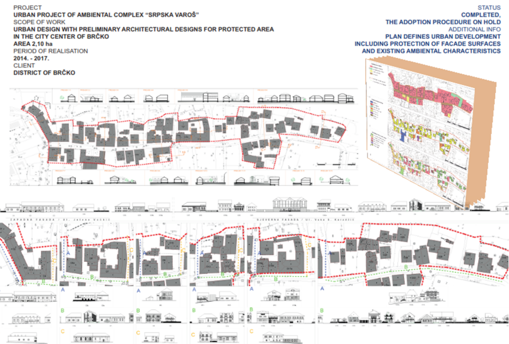
Urban planning project of ambiental ensemble „Srpska Varoš“
Urban planning project with preliminary architectural designs for protected area in the city center of Brčko. Plan defines urban development including protection of facade surfaces and existing ambiental characteristics.
The scope of project development is 2,10 ha.
As an authorized house for performing activities in the sphere of design and planning in the areas of protected cultural and historical heritage IPSA INSTITUTE prepares a detailed planning document Urban planning project of the ambient unit “Srpska Varoš”.
The plan defines the projection of the construction and arrangement of the spatial unit, including the protection of façade surfaces and existing ambient characteristics. The urban design also provides preliminary architectural solutions for newly planned contents.
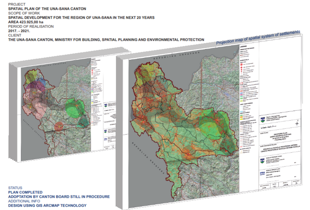
Spatial Plan of Una-Sana Canton for The 20-Year Period
As one of the reference makers of cantonal spatial plans, IPSA Institute worked on the development of the Spatial Plan of the Una-Sana Canton for a period of 20 years.
Spatial development projection and spatial system development projection define the spatial, economic and social development of the Una-Sana Canton area in the planning period with rational use and purposeful management of resources for the space protection.
The projection of spatial development and the projection of the development of spatial systems for the needs of economic development, exploitation of mineral resources, public social infrastructure, infrastructural systems, as well as the development of settlements, defined suitable areas for the development of all functions in the area of the Una-Sana Canton in the 20-year planning period.
The planning document won the Third Prize at the XXIII International Salon of Urbanism in Belgrade in 2014. The award was given in the spatial plans category.
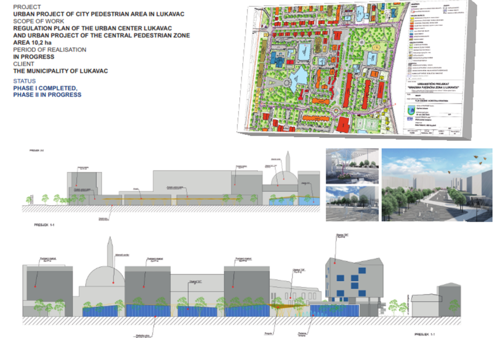
Regulatory plan and Urban Planning Project of Urban Pedestrian Zone in Lukavac
During the period from 2020 to 2023, the Regulation Plan “Lukavac City, Center I and Center II” and the Urban Planning Project “City Pedestrian Zone in Lukavac” were developed for the urban area of the Lukavac city center.
The regulatory plan evaluated the existing situation and defined the projection of the construction and arrangement of the spatial unit. The projection is based on the elimination of identified deficiencies and the targeted improvement of the state of the spatial unit, which significantly increases the quality of life of users of the space.
The urban planning project is a primary urban intervention in the existing urban matrix, which is reflected in the formation of the “City Pedestrian Zone of the City of Lukavac” as the future city center of Lukavac. Establishing the continuity of the urban ground floor with uninterrupted pedestrian communication (about 250m in length) with proper pedestrian and horticultural solutions, adequate business facilities will provide openness of space, better connection with other city areas and a new visual composition suitable for a modern urban city center.
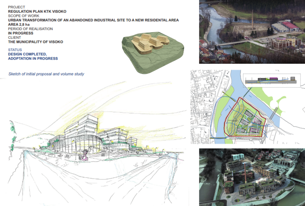
Regulatory plan „Prijeko-KTK“ Visoko and residential area „Prijeko“ Visoko
During 2021 IPSA Institute was engaged in the development of an urban redesign of the existing “brownfield” zone within the urban area of the City of Visoko through the development of a regulatory plan.
Urban transformation of an abandoned industrial site to a new residential area. The scope of project development is 2,8 ha.
Transformation of a residential area. The scope of project development is 41,55 ha.
Development of a Regulation plan with all phases.
The planning document evaluated the existing situation, assessed the possibility of developing the spatial unit and defined the projection of the construction and arrangement of the spatial unit. This projection on free unbuilt surfaces interpolated new contents that upgraded and raised the quality of life within the spatial unit.
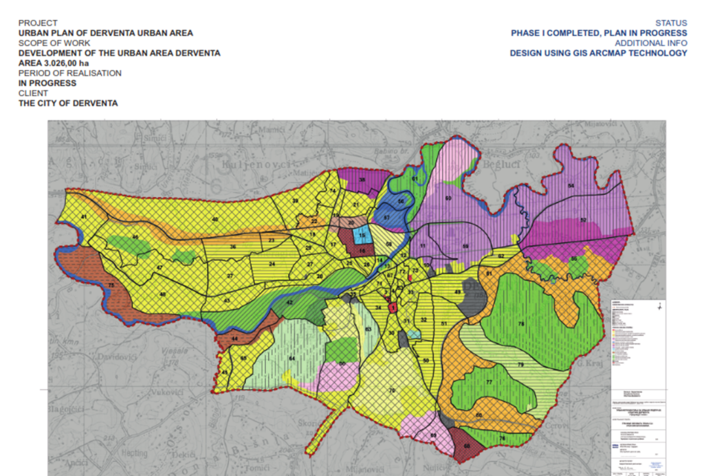
Urban plan of Derventa urban area
Development of the urban area Derventa.
The scope of project development is 3.026,00 ha. Design using GIS ArcMap technology.
During the period 2019 to 2022 IPSA Institute was engaged in the development of a planning document for the urban area of the City of Derventa. After a comprehensive analysis of the observed shortcomings and potential, a planned disposition of the content of housing, work and recreation within the urban area of the City of Derventa was carried out.
The concept of infrastructure development in the planning period enables optimal development of all parts of the narrower and wider urban area.
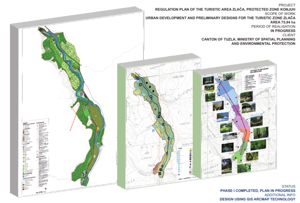
Regulatory plan for the Zlača for the 10-Year Period
As a recognized house for the preparation of spatial planning documentation and environmental protection, in the period from 2020 to 2021 IPSA INSTITUTE has been engaged in the development of the Regulatory Plan “Zlać” in the framework of the protected landscape Konjuh.
The Zlača picnic area is located in the northern part of the Konjuh Protected Landscape and has the role of a transition area – a zone of directed development intended for the development of tourism, sports and recreation within the Konjuh Protected Landscape. Projection of the construction and arrangement of the spatial unit of the Regulatory Plan defines the construction and arrangement of future contents:
- housing capacity for daily, weekly and seasonal stay,
- sports-recreational and excursion capacities,
- public and social infrastructures,
- transport infrastructure for reception, distribution of users within the scope and transit of users to other parts of the Konjuh Protected Landscape.
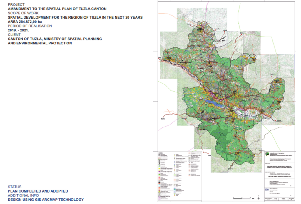
Amendments to the Spatial Plan for the area of Tuzla Canton 2005-2025.
The amendments to the plan updated the existing situation and the changes in area that occurred since the enforcement of the valid Spatial Plan for Tuzla Canton 2005-2025. IPSA INSTITUTE made these updates in period from 2016 to 2021.
Based on the analysis and assessment of the situation, partially changed general and special objectives of spatial development, the amendments were made to the projection of spatial development and the projection of the development of spatial systems in accordance with the provisions of the higher order plan (PPFBIH) and updated sector strategies at the level of the Canton and the Federation of BiH.
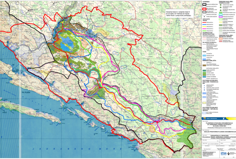
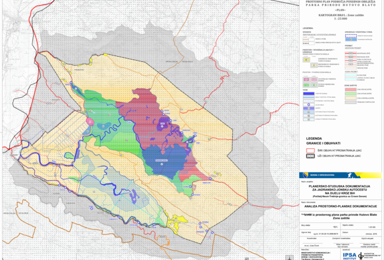
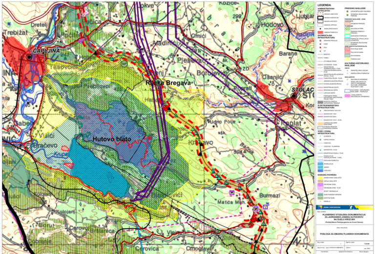
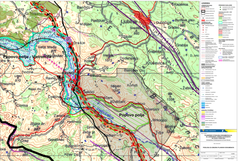
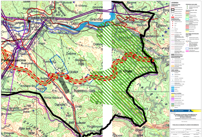
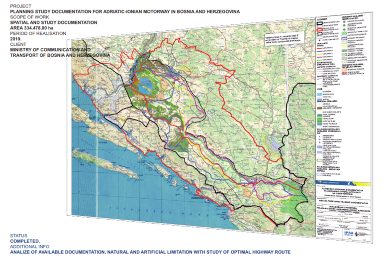
Preparation of planning and study documentation for the Adriatic-Ionian motorway on the part through BiH (Počitelj-Neum-Trebinje - border with Montenegro)
Planning documentation for the Adriatic-Ionic Highway through BiH is first document of its kind to thoroughly study possibilities of this important transport corridor implementation in BiH. This project IPSA INSTITUTE carried out during the period from 2018 to 2019.
Consisting of multiple project parts, with completely new methodology applied, this document should result in complex study whose aim is to achieve best cost/benefit/ecology/environment solution.
First steps of this project were focused on available spatial plans and studies comparison with detailed Restrictions map with accompanying textual analysis. All of it was a good start for Technical analysis of possible solutions for Adriatic-Ionic highway corridor placement.
After Technical analysis finalization, possible solutions are developed through Detailed design.
Importance of the project beside its technical and engineering complexity, rely on analysis of different planning solutions from even different countries, where final accepted solution should reflect best planning strategic, engineering environmental and political possibility.
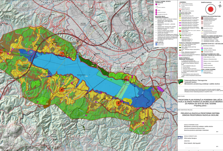
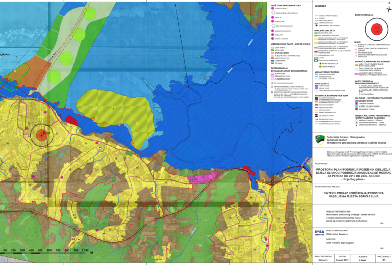
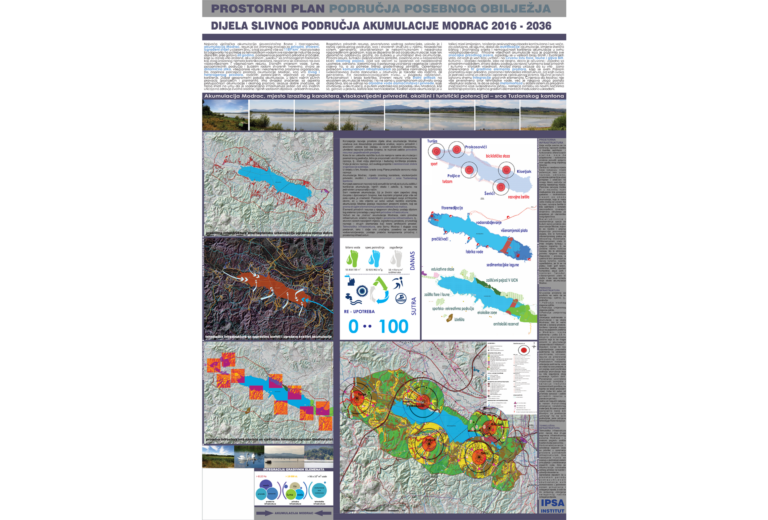
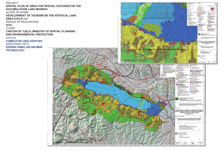
Spatial plan of area for special features on the accumulation lake Modrac
During the period from 2015 to 2019 the IPSA INSTITUTE has been engaged in the development of the Spatial Plan of area with special features for accumulations lake Modrac basin 2016-2036, provides an analysis and explicates how to achieve balance between three basic elements of this complex formation spatial infrastructure, natural infrastructure and technological infrastructure. At the same time, artificial characteristics of the accumulation in regard to both population and industrial water supply, set out priority by law are shaped by planed measures and activities with the aim of presentation, improvement and establishment of sustainable transformation of the area into natural landscape. Achieving equilibrium between artificial functions and natural resources is of the most importance for the future development and reaching full potential of the accumulation Modrac, which will in turn affect a much broader region.
Once artificial lake Modrac became natural and complex ecosystem, with huge possibilities of touristic development scientific exploration and economic growth for the habitants in the gravitational area.
Such a large diversity of life on one side, and built environment on the other, where Modrac lake water is also used as a drinking and technical water resource, needed to be thoroughly evaluated, prioritized and reconsidered for its usage.
The planning document won the First Prize at the XXV International Salon of Urban Planning in Sremska Mitrovica in 2016. The award was given in the category of regional spatial plans and special purpose area plans.
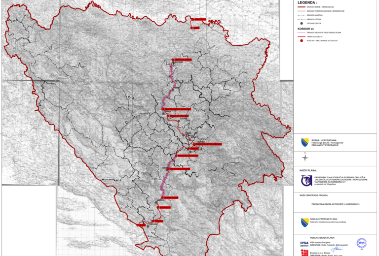
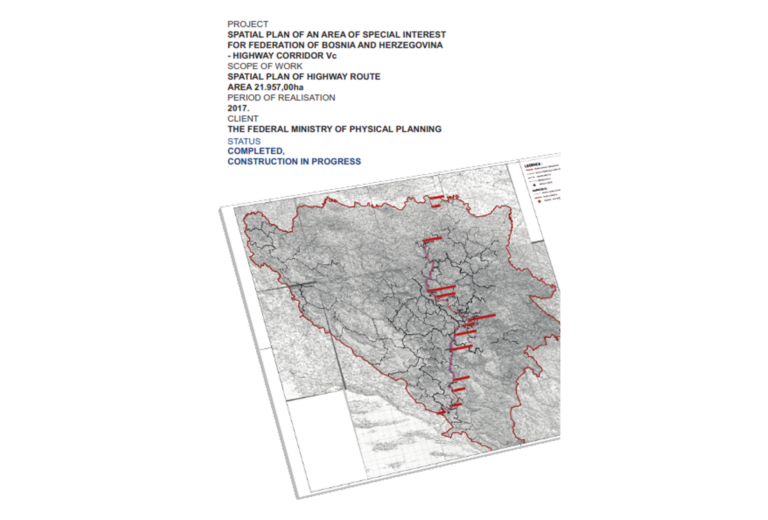
Spatial plan of an Area of Special interest for Federation of Bosnia and Herzegovina – Highway Corridor Vc
During the period 2008 to 2017 IPSA INSTITUTE as the Project developer participated in the development of the Spatial Plan of areas of special characteristics of importance for the Federation of Bosnia and Herzegovina “Highway on corridor Vc”, coordinated by the Holder of preparation of the Federal Ministry of Physical Planning.
Corridor Vc is considered a key transport route in the FBiH which will improve the transport connections of Bosnian-Herzegovinian areas with neighboring countries and regions, and achieve stabilizing and development effects for the entire country.
The spatial plan of the area of special features of importance for the Federation of Bosnia and Herzegovina “Highway on corridor Vc” for a period of 20 years, is a planning document that allows the construction of a highway, determines the purposeful organization, use of land, and defines measures and guidelines for the protection of space within the scope of the Plan. In addition, the Plan directs development and creates the basis for more intensive socio-economic, demographic and economic development in the wider gravitating area of the highway.
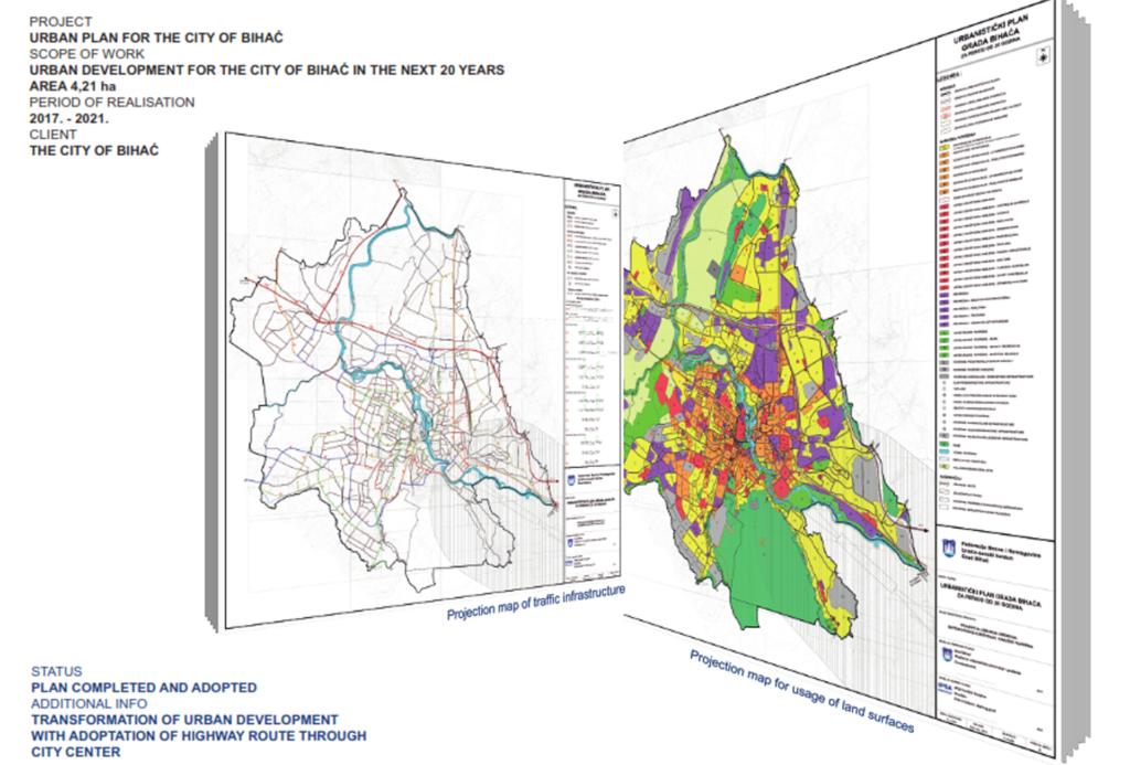
20-Year Period Urban Development Plan of The City of Bihać
During the period from 2017 to 2021 IPSA INSTITUTE has been engaged in the Development of the urban plan projection of the city of Bihać, based on the developmental vision of the City, within the scope of the Urban Plan of the City of Bihać, covering an area of 4,211.52 ha.
Based on the integral analysis of the area state, its valorization, through the urban plan projection, the purpose of the areas within the scope was defined in accordance with the necessary spatial capacities in the planning period. The projection defines zones of reconstruction and transformation within the existing urban matrix, and plans continuous expansion of the city and defines optimal development of infrastructure systems in the 20-year period urban plan.
Regulatory plan „Ravne“ Visoko
In order to plan and direct the development of the archaeological and tourist park Ravne, during 2022 IPSA Institute has prepared a detailed planning document for the area in question.
After the valorization of the area specific spatial, content and infrastructural elements of the development of the archaeological and tourist park Ravne, a park of general importance, were defined in the planning period.
Urban transformation of an archeological-tourist park Ravne, park of general importance. The scope of project development is 28,7 ha.
Development of a Regulation plan with all phases.
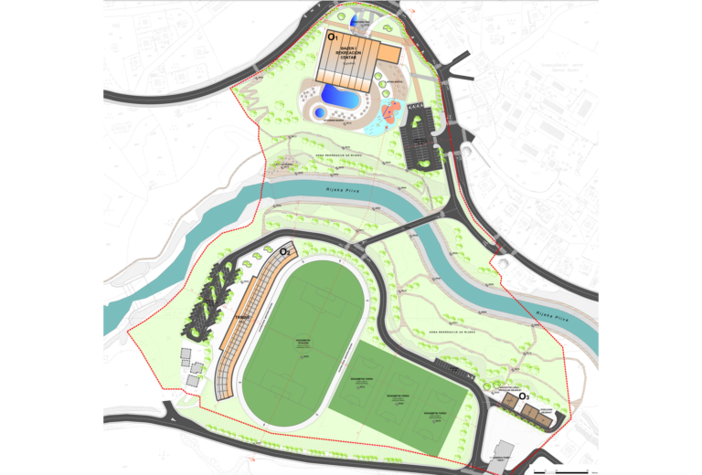
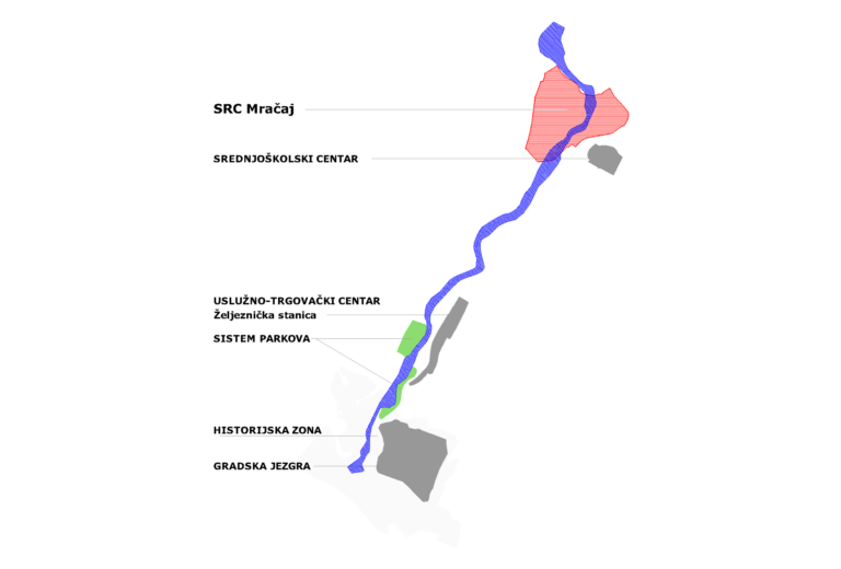
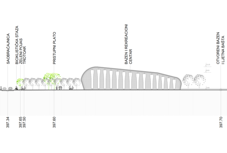
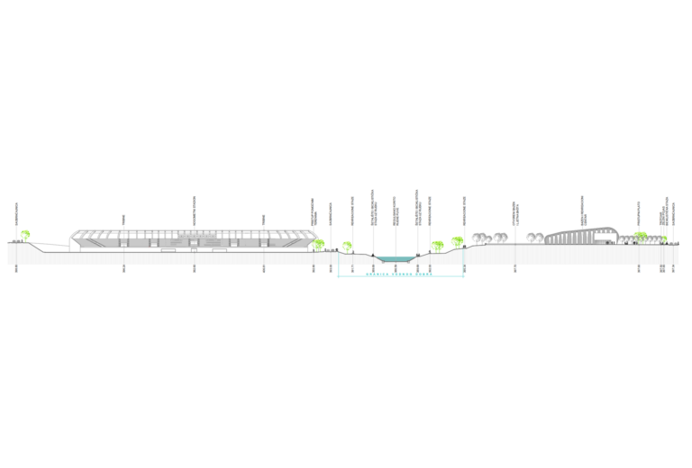
Urban Planning project "Sports and recreation center Mračaj" Jajce
For the purpose of transformation and improvement of the space of the “Sports and Recreation Center Mračaj” in the municipality of Jajce, during the period 2014-2016 IPSA Institute has prepared a detailed planning document at the level of an urban project.
The scope is specific for its position in the flow system of the Pliva River. The scope divided by the river Pliva has certain obstacles, which are reflected in the difficult formation of mutual connections between organized contents and the limitation of pedestrian flows. The advantages of such morphological frameworks are reflected in the presence of water as an element that has a significant contribution in terms of completing the ambience and landscape as an important and integral element of the whole.
The urban plan defines the basic spatial conditions for the formation of a sports and recreation center within the Mračaj sports zone. The new spatial structures are organized into two separate units: a sports center on the left bank and a football stadium with stands on the right bank.
The urban concept is based on:
- Formation of sports content zones that allow unhindered use independently of each other (football stadium with bleachers and sports center with swimming pools).
- Forming a physical and functional connection between the contents that are being developed on the two banks of the river (pedestrian-vehicle bridge).
- Possibilities of spatial connection (opening) of the complex to the environment, but also enabling the independent functioning of some of its structures
- Affirmation and revitalization of the coastal area of the Pliva River by laying out pedestrian and bicycle paths, as well as rest areas with adequate urban furniture.
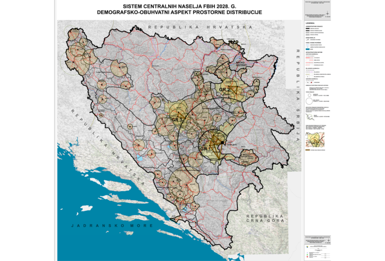
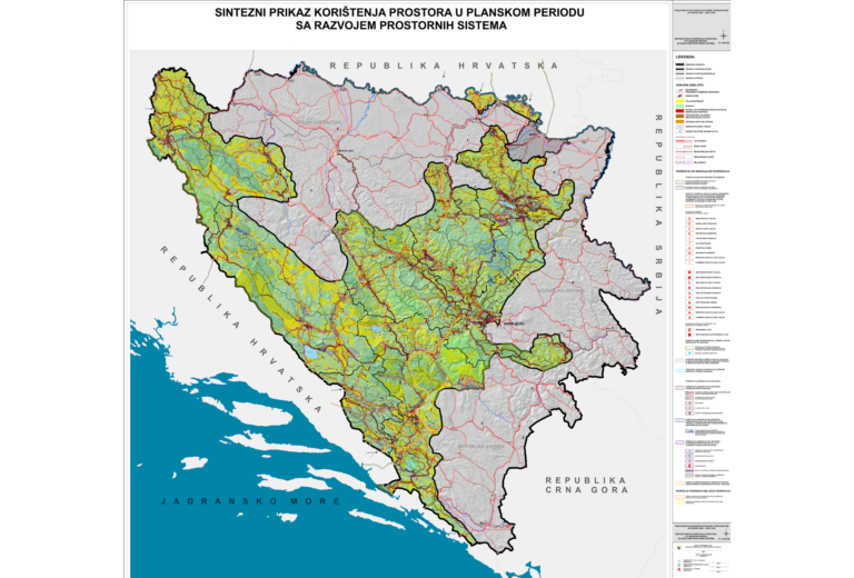
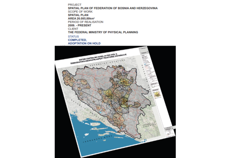
Spatial Plan of Federation of Bosnia and Herzegovina for a period of 20 years
IPSA Institute in consortium with the Urban Planning Institute of Bosnia and Herzegovina and Ecoplan in 2014, as the Holder of Drafting, started activities on the development of the Spatial Plan of the FBiH. Due to different interpretations of legal and constitutional provisions, the process of drafting the Plan has been in the final stage for a long period of time.
Spatial plan of Federation of Bosnia and Herzegovina is main planning document for entity. Strategical approach and development tools of planning procedures and practices ensured sustainable planning of Federation for the next two decades. Spatial plan consist of two phases:
I – detailed detection and analysis of existing conditions, comparations with previous strategic solutions and their evaluation,
II – proposal of new planning solutions, compliant with contempory economical, ecological, social, environmental achievements, and with nature and biodiversity preservation obligations on global level.
Spatial plan of Federation of BiH is digitalized and GIS base made model with endless possibilities for its upgrade, as well as modifications according to new knowledges and data gathering. This is one of first of its kind software usages in Bosnia and Herzegovina for planning documentations. Multidisciplinary approach, contemporary solutions, new legislatives incorporation, and fundamental strategic axes which have been set by this main planning document, serve as obligatory base for all other plans in FBiH, making synchronization of planning solution and their more detailed development possible.